Se hai scelto di non accettare i cookie di profilazione e tracciamento, puoi aderire all’abbonamento "Consentless" a un costo molto accessibile, oppure scegliere un altro abbonamento per accedere ad ANSA.it.

Ti invitiamo a leggere le Condizioni Generali di Servizio, la Cookie Policy e l'Informativa Privacy.

Puoi leggere tutti i titoli di ANSA.it
e 10 contenuti ogni 30 giorni
a €16,99/anno

  • Servizio equivalente a quello accessibile prestando il consenso ai cookie di profilazione pubblicitaria e tracciamento
  • Durata annuale (senza rinnovo automatico)
  • Un pop-up ti avvertirà che hai raggiunto i contenuti consentiti in 30 giorni (potrai continuare a vedere tutti i titoli del sito, ma per aprire altri contenuti dovrai attendere il successivo periodo di 30 giorni)
  • Pubblicità presente ma non profilata o gestibile mediante il pannello delle preferenze
  • Iscrizione alle Newsletter tematiche curate dalle redazioni ANSA.


Per accedere senza limiti a tutti i contenuti di ANSA.it

Scegli il piano di abbonamento più adatto alle tue esigenze.

5 million hectares of Amazon rainforest lost in 5 years

5 million hectares of Amazon rainforest lost in 5 years

Deforestation documented by European Sentinel-1 satellites

16 marzo 2023, 18:57

Redazione ANSA

ANSACheck

The Amazon rainforest, view from the International Space Station (credit: ESA/A.Gerst, CC BY-SA 3.0 IGO) - RIPRODUZIONE RISERVATA

The Amazon rainforest, view from the International Space Station (credit: ESA/A.Gerst, CC BY-SA 3.0 IGO) - RIPRODUZIONE RISERVATA

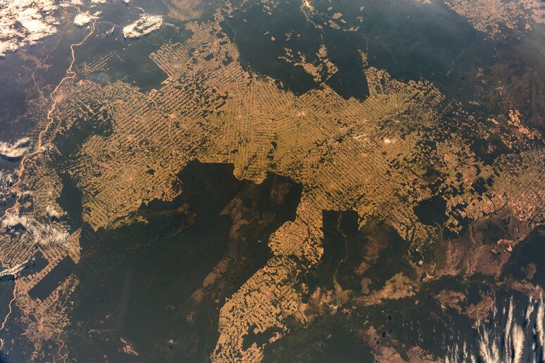
From January 2017 to November 2021, the Amazon rainforest shrank by over 5 million hectares, an area roughly the size of Costa Rica, according to billions of radar images acquired by the Sentinel-1 satellites of Copernicus, the Earth observation program of the European Space Agency (Esa) and the European Commission. 

The Sentinel-1 mission has been monitoring the health of tropical forests around the world with unprecedented regularity since 2015, acquiring millions of gigabytes of data day and night, including in the presence of cloud, fog, smoke or aerosols, that allow deforestation updates every 6-12 days at a resolution of 20 meters.

Thanks to the 'Sentinel-1 for Science: Amazonas' science project coordinated by Esa, more than 450 terabytes of data have been converted into a 'data cube’, a multidimensional data structure allowing a dynamic analysis of deforestation in the Amazon basin, with a map showing the loss of more than 5.2 million hectares in less than five years. 

“What we are seeing from space is over a million hectares of tropical moist forests disappearing each year in the Amazon basin, with the worst year being 2021 in Brazil. We can track these losses and report on them transparently and consistently every 12 days henceforth,” says Neha Hunka, Remote Sensing Expert at Gisat, a partner in the project.

The next goal will be to quantify carbon loss based on changes in land cover, in collaboration with Esa's Climate Change Initiative team.

Riproduzione riservata © Copyright ANSA

Da non perdere

Condividi

O utilizza